
I
t was an idyllic childhood on the Homer Spit that Mo Hillstrand enjoyed during the summertime, when her parents, Mary and Earl Hillstrand, original owners of Land’s End, ran the hotel.
Beginning with the hotel’s opening in 1958, the family would migrate down from Anchorage each summer and live in an apartment above the lobby. Hillstrand remembers making driftwood forts, swimming in ponds, and playing games of tag across the tops of tall stacks of crab pots.
It wasn’t so idyllic after the 1964 earthquake, which turned the gravelly wisp of land into liquid when Hillstrand was 12 years old. She has a nightmarish memory from the spring after her family returned to the Spit to find the hotel broken into three pieces that were partially submerged at high tide. One evening, Hillstrand’s parents went into town for dinner and left her alone in a cabin at the end of the Spit where they were staying temporarily. As the tide came in, water rose up all around her. Hillstrand kept checking the tidebook as the flood tide cut off the tip of the Spit and the sea surrounded her on all sides.
“There was no question that everything had changed,” she said.
The Spit formed as a terminal moraine, which is the pile of sand, gravel and other debris dropped at the foot of a glacier. That glacier is long gone, but the Spit continues to be changed by sediments, currents, weather and human activity.
Steve Baird, a scientist with the Kachemak Bay Research Reserve, described how sand and gravel flow
down the Spit on both sides: on the west side, from Anchor Point, prevailing currents bring sediments out of the Anchor River and off the bluffs down the Spit’s west side to the tip. Baird referred to underwater imaging created by the National Oceanic and Atmospheric Administration (NOAA) that shows a landslide of material off the tip of the Spit into a deep trench in the ocean floor.
Some of the sand and gravel, Baird said, most likely continues around the Spit. This material, combined with sediments that travel down the Spit on the east side, clog the mouth of the harbor, requiring regular dredging.
Aerial photos used in Baird’s work show that parts of the Spit are eroding while others are being naturally bolstered. On the west side of the Spit, that distinction is drawn right around the Central Charters building, which sits opposite Harbor Ramp 3, about half a mile from the end of the Spit: to the north, the Spit is generally losing material; to the south, it is on average gaining. At its tip, the Spit is getting longer by an inch or two a year.
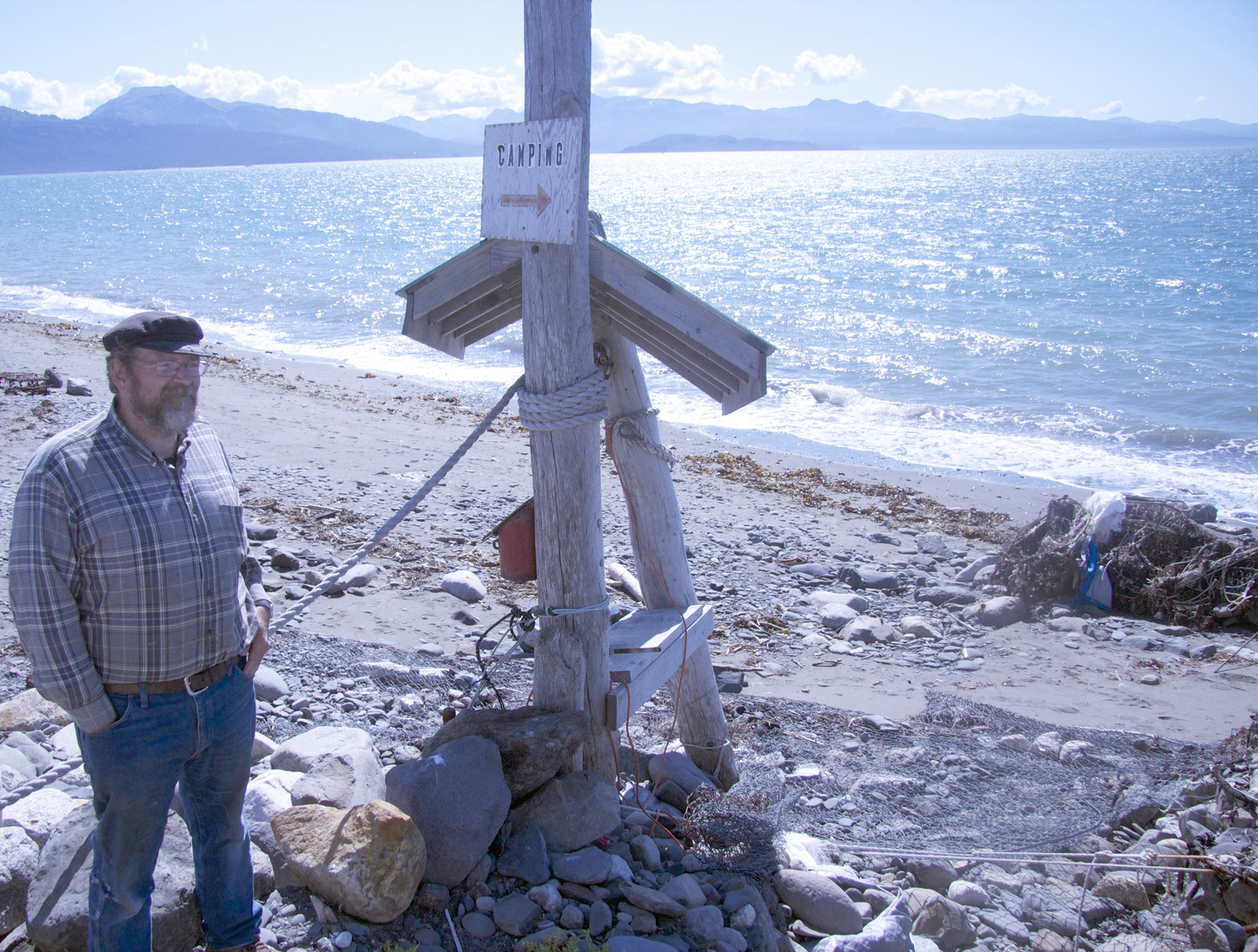
Dan Young doesn’t need to refer to aerial photos to know what has happened to his Spit property. He and his wife Pam are the owners of what was an RV campground on the west side of the Spit opposite the Fishing Hole.
For 15 years, the Youngs operated a campground with 10 sites, all hooked up to electricity. Today, there’s little left of the campground other than a sign that says “CAMPING” with an arrow pointing to a tangled heap of rubble that gets washed over by storms.
The Youngs started noticing erosion on the property a year or so after buying the 1-acre parcel. So Dan Young set about trying to stave it off. He started by filling gabions — steel wire baskets — with rock on the seaward side of the campground. Then he backfilled with more rock. By wheelbarrow and three-wheeler, he slowly built up a barrier between his property and the sea.
Each winter, a large storm would invariably wash over the top of the property, but repairing his homemade seawall each spring was part of what Young considered normal work to get ready for the season.
“At $25 a campsite, you can’t make any money if you hire someone to do the work,” he said. “But if one stubborn, crazy guy can move enough rocks, you can justify being out here.”
When the price of steel jumped, Young switched to filling old crab pots with rock. He laid down Typar to retain sand and wrapped chain link fencing around the rock-filled structures. But as storms washed rocks down the beach, they would slice the steel wire and fencing.
Young estimated that he used eight quarter-mile rolls of wire annually to make repairs. Even when the structure itself was intact, the gravel on top of it was soft. He had campers park their vehicles on sheets of plywood to avoid sinking their tires.
The Youngs operated their campground until last summer. But last winter, storms thrashed the property so fiercely it finally gave way. There’s no beach left to drive an RV on, let alone to pitch a tent.
Young feels that the state Department of Transportation’s riprap project north of his property played a role in the demise of the campground. That project, which was completed last summer, laid large boulders from the beach to the road level along a 400-foot section of the Spit and added smaller rock at the road level and along the beach close to the Youngs’ property. Dan Young said he observed rocks from that project tumbling down the beach, dicing his wire structure. He no longer could keep up with repairs.
“When I started this whole process, I knew I’d be fighting the ocean. But I didn’t know it would be like this,” he said.
Dan Young doesn’t want anyone to feel sorry for him or to think he’s blaming someone else for his troubles. “I don’t have a whole lot of hard feelings about what happened, ” he said.
He is sensitive about the fact that his property has become an eyesore. He plans to clean it up as soon as he and his wife figure out what they want to do next with the property. He’s pretty sure that they won’t try to recreate what they had.
“Gabions are not going to work anymore. I’ve got to go to Plan B,” he said.
The photos researcher Steve Baird has used in his work show that this campground area has eroded about 100 feet in the last three decades. The Youngs’ property is among a handful of private parcels on the west side of the Spit that are slowly disappearing from erosion.
Coastal erosion is “a pretty hard process to stop,” Baird said. “And if you do stop it, there are unintended consequences.”
The coming years and decades will mean more changes to the Spit.
Another large earthquake or tsunami could, of course, cause catastrophic changes to the Spit.
But the Spit is also changing constantly and incrementally. Like land around the bay, it is rising a little bit each year, due to tectonic forces and from the melting of glaciers, which makes the land buoy up from underneath.
A monitoring station on the east side of the harbor has measured an annual rise of about 5.6 millimeters, a little bit less than a quarter of an inch. But rising global temperatures and melting ice sheets are making global sea level rise too — about 3 millimeters, roughly one-tenth of an inch each year.
According to NOAA, the rate of sea level rise may be increasing.
Will the Spit be able to outpace this rising tide?
“There are lots of unknowns,” Baird said.
Miranda Weiss is a Homer writer.
