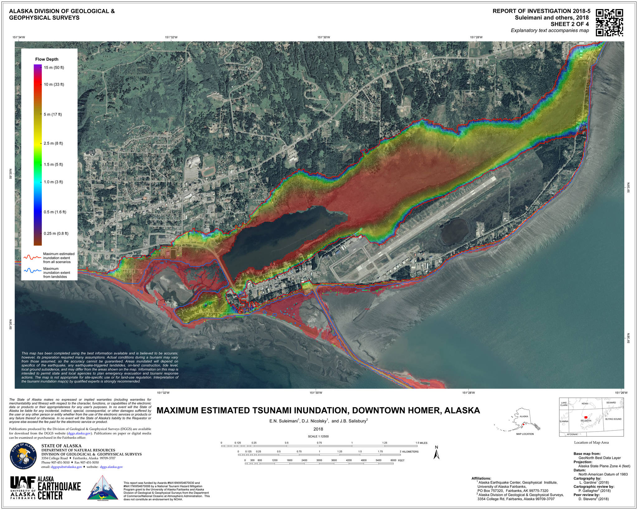
With new maps showing changed tsunami inundation zones and two evacuations held last year after earthquakes struck Southcentral Alaska, the upcoming Tsunami Awareness Week takes on extra meaning.
The City of Homer has several events planned March 24-30 to help residents understand where to go uphill to escape a major tsunami.
Last October, scientists with the Alaska Earthquake Center of the University of Alaska Fairbanks and the Alaska Division of Geological and Geophysical Surveys released a report and new maps revising tsunami inundation zones for Homer and Seldovia. The new maximum inundation zone, or blue line, is at 50 feet above sea level, and generally includes all of the Homer Spit and the area around Beluga Lake and Beluga Slough. The zone ends below the site of the new Homer Police Station on Heath Street and Grubstake Avenue.
In the past, residents had been told to evacuate to above Pioneer Avenue, a prominent landmark that would provide no confusion in in the event of a tsunami.
“But Pioneer Avenue is well above the blue line, causing confusion and unnecessary evacuations for residents, schools and businesses located below Pioneer Avenue, but above the maximum inundation zone,” according to a press release.
Tsunami Awareness Week events in Homer will help residents better understand new inundation zones.
“Tsunami awareness activities throughout the week will highlight tsunami preparedness, and bring particular attention to Homer’s 50-foot tsunami ‘blue line’, because knowing if you are in the danger zone and where to go during an evacuation is crucial to survival,” said Jenny Carroll, the City’s Public Information Officer, in a press release on Monday. “When you cross above the blue line, you enter a tsunami safe zone.”
Events planned include:
• Call-in radio shows with Homer Police Chief Mark Robl and Homer Acting Fire Chief Robert Purcell at 10 a.m. March 27 for KBBI’s Coffee Table and at 1 p.m.
• A Tsunami Blue Line Fun Run/Walk at 10 a.m. Saturday, March 30, starting at the Homer Elks Lodge. The 2.66-mile round trip course roughly follows the 50-foot elevation blue line through Homer from the Homer Elks Lodge around Ben Walters Park and back. Registration starts at 9 a.m.
Blue Line stations will be set up along the route to mark where Homer’s roads cross the blue line. Participants are encouraged to collect a stamp at each station. Run/walk participants with a full set of stamps are eligible for prize raffle drawings of emergency Grab & Go Backpacks donated by Ulmer’s Drug & Hardware and NOMAR. Wells Fargo Bank will host a refreshments table at its blue line crossing. Participants are encouraged to wear blue.
According to City Manager Katie Koester, the Blue Line event is inspired by Blue Line projects developed in New Zealand and duplicated in several Oregon communities where permanent blue lines are painted on street pavement to clearly mark the point citizens should evacuate past during a tsunami warning, according to City Manager, Katie Koester.
“Blue lines are a visible, easily understood reminder to residents: Don’t slow down until you pass this line because a major tsunami event will make it here,” Koester said in the press release. “However, because we are in snow country, for the long-term, the city will permanently mark Homer’s evacuation routes with additional route signs and Safe Zone signs which are visible year round. Until that happens, our outreach this week makes Homer’s blue line temporarily visible and brings greater awareness.”


