This is the second installment of the series, “A Soils Primer” for the Homer area. This is meant to be a non-technical, for the most part, introduction of the Fab Four of Homer soils.
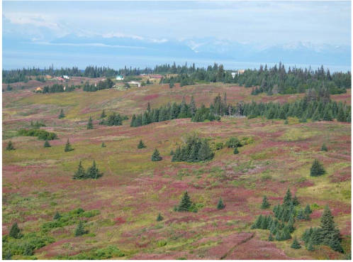
The rolling hills that stretch north from the bluffs above Homer to the Deep Creek watershed are predominately cloaked by grasslands, fireweed and scattered stands of spruce. These soft hills are blanketed by Kachemak soils. Those of us that have had the good fortune to live with these pleasant soils can attest to some of their wonderful properties. For those of you that have only worked with poor soils, scripture says nothing against coveting thy neighbor’s soil. While this series of articles focuses on soils, the ecologist Aldo Leopold noted, “Land is not merely soil, it is a fountain of energy flowing through a circuit of soils, plants and animals.”
So where do these soils come from and how did they form? Out to the west across Cook Inlet stand the volcanoes of the Alaska Range. Usually these silent sentinels are just that: silent. Occasionally they roar to life, reminding us that they are geologically active. My introduction to volcanism was on the morning of March 27, 1986 when Augustine Volcano erupted. A huge menacing black cloud soon enveloped Homer and spread rapidly to the north. Then the billowing clouds began dropping their gritty abrasive cargo. For many of us this rude introduction provided a reality check on the nature of volcanic ash. Some of the immediate effects were irritation of eyes and lungs, if not protected, and havoc to internal combustion engines. Lingering effects were often encountered when attempting to cut gritty lumber or wood from uncovered stacks and cleaning clogged roof gutters and footer drains for months or longer. On the bright side, new soil was being formed.
There are five interacting soil forming factors: parent material, climate, landscape position, living organisms and time. Parent material is a dominate factor in the formation of Kachemak soils and is responsible for many of its properties. The topsoil and underlying couple of feet of these soils (the solum) is composed of weathered volcanic ash with varying amounts of wind deposited glacial silt from outwash plains of receding glaciers. This accumulation has been an ongoing process, on stable landforms, for thousands of years. The substratum of these soils is glacial till or the stratified Tertiary deposits of the Kenai Formation. The volcanic ash from our local volcanoes is composed dominantly of silica in the form of volcanic glass that weathers rapidly into an amorphous soil material. It has unique properties including low bulk density, high porosity and an affinity for organic carbon. These properties make these soils easy to till, quick to drain after rainfall events, and provide exchange sites for holding and releasing nutrients to the plants. The thick dark brown solum gives the appearance that these are soils with a healthy soil biome. That first impression is correct. Gardeners love these productive soils that are without rock fragments, poor drainage and high clay content. Contractors also love these soils. They are easily excavated and normally do not have a water table within 6 feet of the surface.
Soils are no different from other components of the natural world, or human nature. They also have their faults. In addition to an affinity for organic carbon, these volcanic ash soils also have an affinity for phosphorous. They bind it tightly and make it unavailable for the plants. These soils are also acidic and naturally infertile. This can be easily remediated through liming and fertilization.
It is more difficult to mediate the physical properties of the solum. The amorphous material has a “card house” or random structure that has low shear strength and bearing capacity. Thus, they are not suitable as a base for foundations or pilings. This material, with high organic carbon, is better suited for lawns and gardens.
Compaction of the solum is an issue from heavy traffic on well used trails. The Watermelon and Homestead trails are examples that are great when they are dry. However, they can be as treacherous and slippery as ice when wet.
If you are interested in the technical details of soils a wealth of information is available from Natural Resources Conservation Service (NRCS) at https://www.nrcs.usda.gov/wps/portal/nrcs/main/soils/survey. Soil Survey reports and maps for the Western Kenai Peninsula (Homer to Point Possession), the Lower Kenai Peninsula (Jakolof Bay to East Chugach Island), and most counties in the United States are also available through the link above.
The U.S. soil survey program began in 1899 and continues today. Surveys are updated as technology develops.
Doug Van Patten, a retired soil scientist, had the pleasure of exploring, classifying and mapping soils throughout Alaska, and parts of Montana, Hawaii and Florida for 40 years.
He moved to Alaska in 1976 from Montana, worked as a soil scientist/project leader for 30 years with USDA/NRCS, followed by 10 years of part-time work as a senior soil scientist with various private consulting firms including HDR Engineering and Three Parameters Plus, Inc.


