
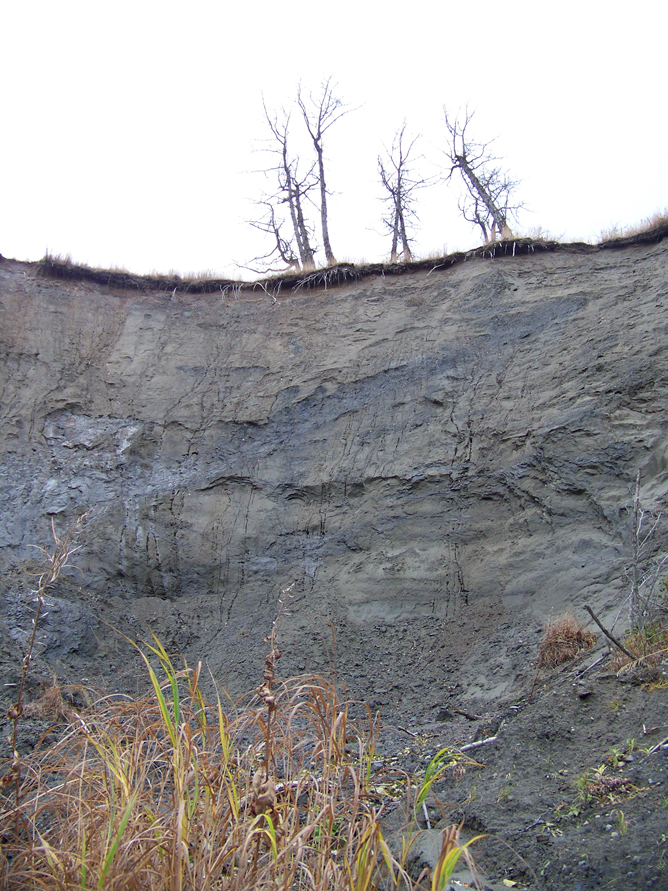
From the beach, the walls of this naturally created amphitheater rises 100 or more feet. Cottonwood trees, where eagles occasionally perch, cling to a portion of its rim. Gurgling water can be heard making its way down the vertical slope and flowing through a growth of alder toward Cook Inlet.
Standing at the base of the bowl, in ankle-deep quicksand-like mud, the setting is picturesque.
Standing at the top, where pink-taped survey stakes mark the diminishing distance between the edge of the bluff and the 55 mile-per-hour traffic on this section of the Sterling Highway, the perspective is not so appealing.
“The bluff is eroding at a significant rate because of water coming out of the embankment,” said Hannah Blankenship, information officer for the Alaska Department of Transportation and Public Facilities. “It’s at a point where we’re concerned about the stability of the highway.”
Work on the department’s Sterling Highway Erosion Response Project Milepost 150-157 began in 2010, with an evaluation of solution alternatives and associated costs. The plan calls for:
• Excavating saturated material from the base of the eroding area;
• Constructing a riprap layer to stabilize the slope and provide a course for the flow of groundwater;
• Placing topsoil and revegation.
Eric Miyashiro, DOT&PF project manager, said engineering and consulting firm Dowl HKM has recently been hired to finalize the design plans.
The department also is in the process of purchasing the single privately owned parcel impacted by the project and “should have an offer (to the property owner) relatively soon,” said Miyashiro.
Bidding for the actual construction work will take place next summer, with construction to be done in the fall of 2014.
“We believe that erosion is coming from the soil strata near the top and leaks halfway up the side of the cliff,” said Miyashiro. “When that happens, it keeps eroding the face of the cliff and keeps getting closer to the road each year.”
The distance between the highway and the edge of the bluff was estimated at 45-50 feet in October 2012 by DOT&PF project manager Gerry Walsh. At that time, local geologist Ed Berg described the features that make this area vulnerable to “liquefaction.” Basically, according to Berg, a water-saturated sand layer sits on an impermeable concrete-like glacial till. Given those conditions, the speed of the erosion could be magnified in the event of a seismic shake.
“An earthquake lifts up the ground and would take the pressure off the sand grains so they are essentially floating in water,” said Berg. “Something like that would take out hundreds of yards of the bluff. There really isn’t much you can do about that.”
Currently, survey stakes spaced approximately 10 feet apart, indicate a 40-foot margin between the firm edge of the road and open air.
“It’s eroding quick enough so that folks are alarmed, more than a foot a year,” said Miyashiro.
According to the state’s plan, riprap placed a little higher than the layer that’s weeping water would allow the water to stay below the surface and flow right through to the bottom of the hill “without causing more erosion,” said Miyashiro, adding that a cover of topsoil and vegetation “should give a nice stable face.”
How long that stability will last is another matter, however.
“At least within our lifetimes,” said Miyashiro. “One day, who knows, but that should take care of the immediate problem for the foreseeable future.”
McKibben Jackinsky can be reached at mckibben.jackinsky@homernews.com.
