

The Pratt Museum’s latest exhibit, cARTography, makes a typeface play, emphasizing “art” in the word. That also pays respect to the tradition of defining the geographic world on paper — on, in modern technology, in digital form. While there can be technical precision in acquiring data to make maps, how a cartographer uses line, shading, color and perspective to illustrate that information speaks as much to the map maker’s artistic vision.
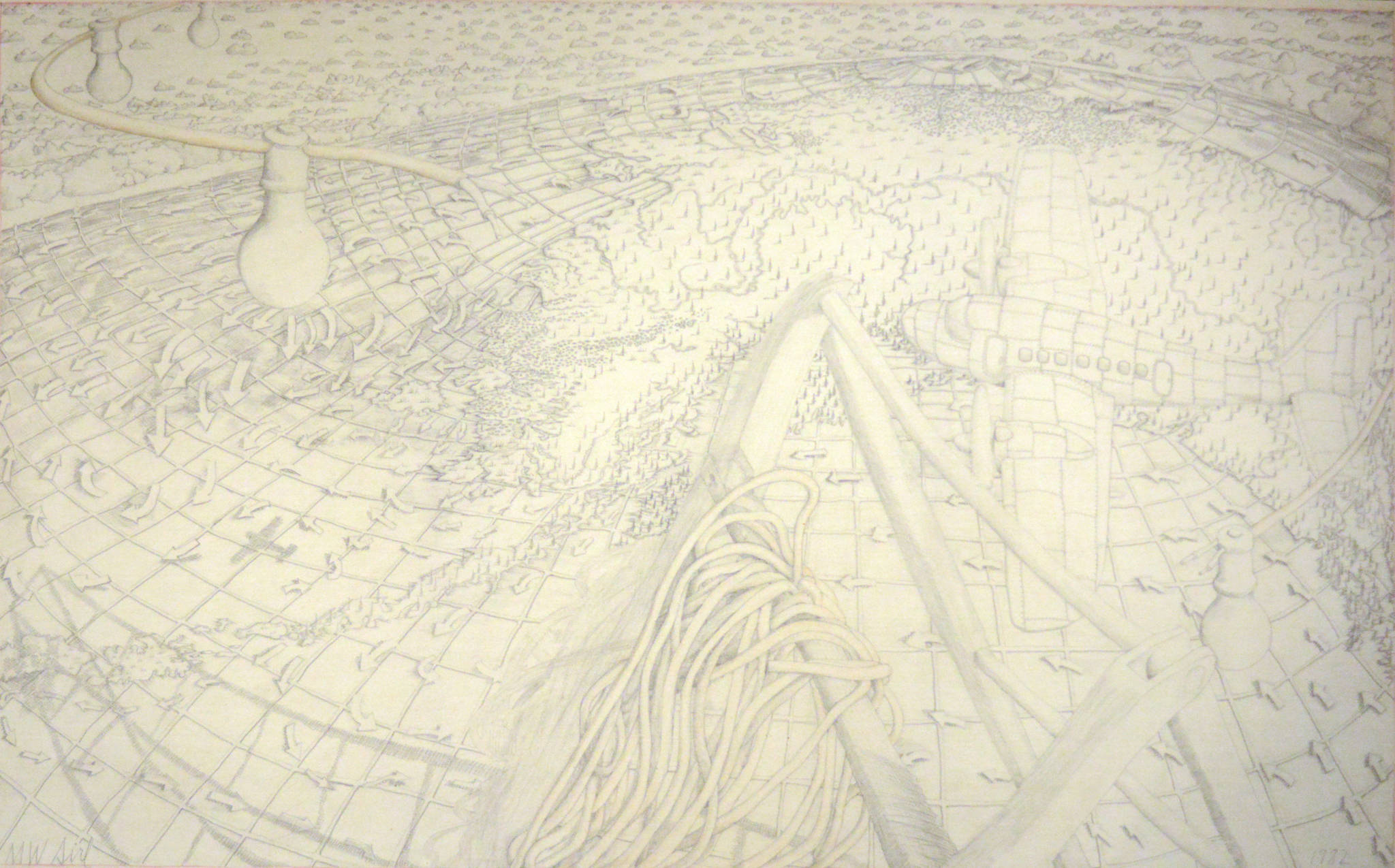
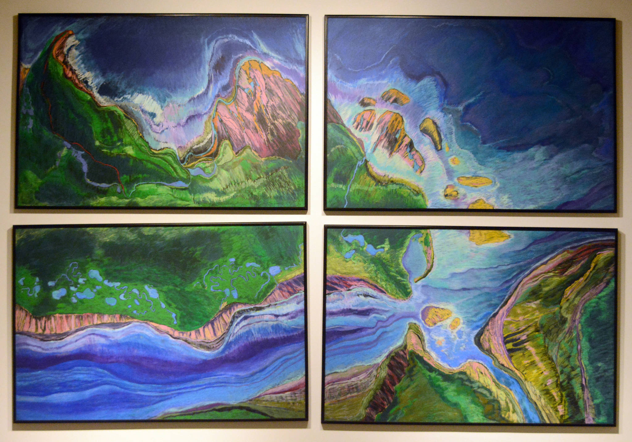
Showing through the end of the year, cARTography pulls together artifacts, maps and art from the Pratt collection to make that point. The show includes technical tools of surveying, and even a historic Homer Spit boundary stone, as well as beautiful maps. True to its mission of exploring Kachemak Bay as a place, cARTography also features paintings and quilts that show how Homer’s artists have incorporated geographic elements into their work. Curator of collections Scott Bartlett said the exhibit was partly inspired by several acquisitions, notably two large works by former Homer artist Mike Sirl, “The Grid Land” and “Points North.” “The Grid Land” shows a globe view of Alaska with lines of latitude and longitude superimposed over it — a map that can be art or art that can be a map.
“It’s totally a map, but it’s also drawn from memory. He’s making it look like a map, a globe with its three-dimensional quality, a mash-up of an actual aerial view and a map,” Bartlett said.
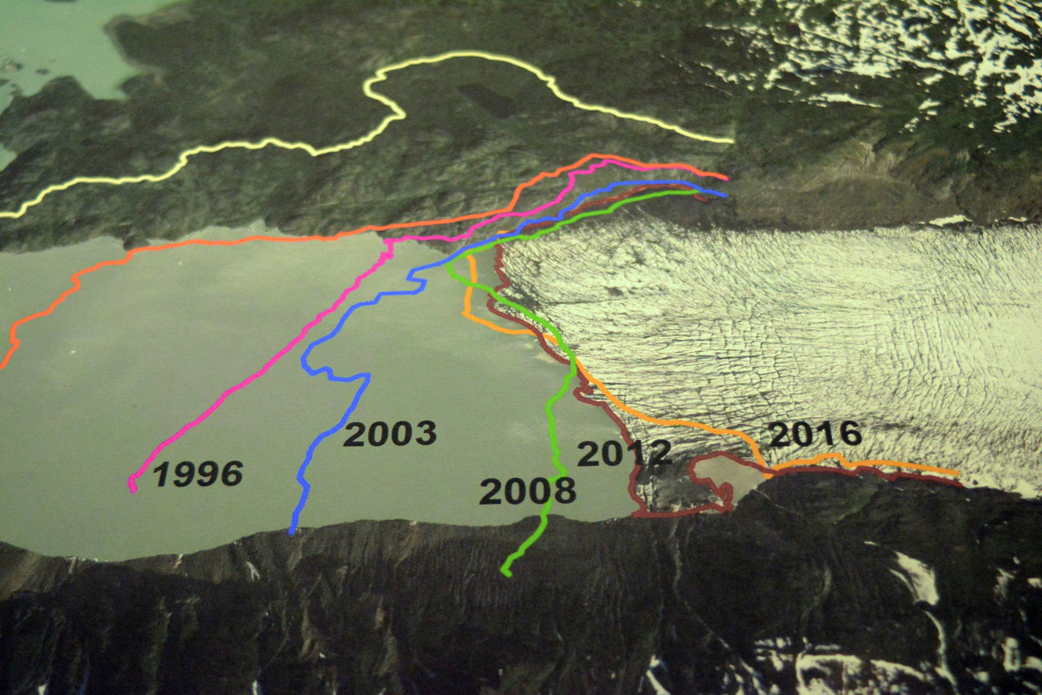
Sirl’s art offered an entry into showing maps from the Pratt’s collection, including a 1900 map of the Cook Inlet Coal Fields Company’s map of the railroad from near West Hill Road to the end of the Homer Spit. Bartlett said he also was excited to bring in some contemporary maps, such as a 2016 GIS — geographic information system — map showing the retreat of Grewingk Glacier made by Steve Baird of the Kachemak Bay Research Reserve.
cARTography also includes art created in response to events, such as Karla Moss Freeman’s “Wild Alaska,” painted during the 1989 Exxon Valdez Oil spill. Other artists created work as part of calls to enter Pratt themed exhibits, such as Mike Murray’s watercolor painting, “Tide Table,” for the Living by the Tides show, and Kathy Smith’s “Ice Maps,” for the Concerning Climate Change show. Many art works were purchased by the Pratt using a Rasmuson Foundation grant.
Like the railroad map, another work, an annotated mariner chart, presents a historical perspective. Meticulously labeled and hand drawn and colored on a 1941 nautical chart of Cook Inlet, the map shows the location of fish trap areas and canneries.
“One of the cool discoveries for me in selecting artifacts for this was that pair of maritime charts,” Bartlett said of those maps. “It falls into the realm of the practice of mariners making corrections to charts.”
The exhibit also includes a map lover’s dream: a cabinet of maps laid flat that show things such as the homesteads of Homer.
The Pratt has long had an association with quilting. Each year, local quilters collaborate on a quilt as a fundraiser for the museum. Like Murray’s illustration of tide changes, one quilt shows the progression of time as seen over the four seasons. Another quilt, “Georg Wilhelm Steller: Voyage to the North Pacific, 1741-1742,” shows movement of time, the voyage of the Vitus Bering expedition that Steller sailed on. That quilt also depicts the animals Steller described.
That’s an interesting angle to cARTography: it’s a show as much about time as it is about space. A history museum by its nature tracks time through artifacts and exhibits, each piece marking a moment in history. Art and maps also can chronicle change, many moments in one piece.
“Steve’s GIS stuff is a good example of that because it includes time with the glacial erosion and the bluff erosion in particular,” Bartlett said.
That’s the overall effect of the exhibit as a whole. It presents many perspectives of the lower Kenai Peninsula, many moments as depicted in maps. Taken together, as the visitor moves through the cARTography exhibit, they understand an elemental truth of our home. We live in a land being changed and changed by the forces of nature and culture.
Reach Michael Armstrong at michael.armstrong@homernews.com.
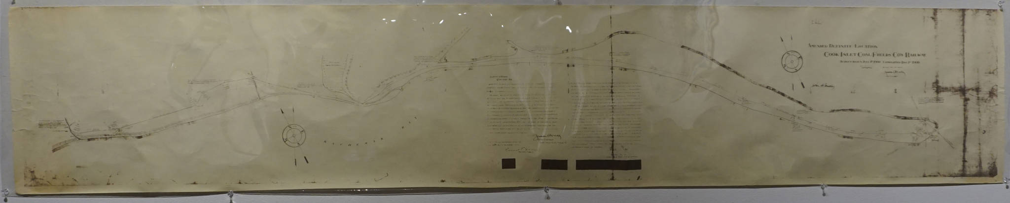
A 1900 map of the Cook Inlet Coal Fields railroad is one of the historic pieces included in cARTography exhibit, shown Tuesday, Aug. 22, 2017 at the Pratt Museum, Homer, Alaska. (Photo by Michael Armstrong, Homer News)
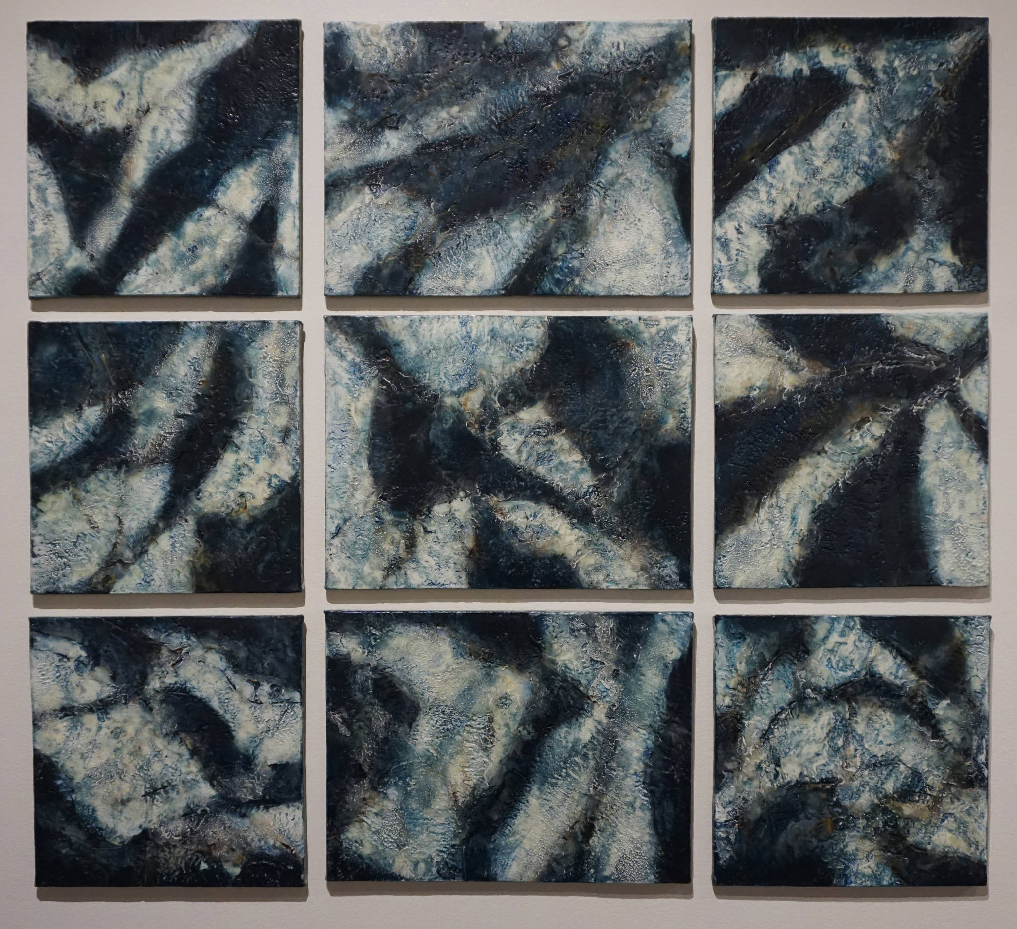
Kathy Smith’s encaustic painting, “Ice Maps,” depicts disintegrating ice fields Tuesday, Aug. 22, 2017. It’s part of the Pratt Museum’s “cARTography” exhibit. (Photo by Michael Armstrong, Homer News)

Mike Sirl’s “The Grid Land,” shown Tuesday, Aug. 22, 2017 was one of the art works that inspired cARTography, an exhibit at the Pratt Museum, Homer, Alaska. (Photo by Michael Armstrong, Homer News)
Mike Sirl’s “Points North,” shown Tuesday, Aug. 22, 2017 was one of the art works that inspired cARTography, an exhibit at the Pratt Museum, Homer, Alaska. (Photo by Michael Armstrong, Homer News)
Karla Moss Freeman’s “Wild Alaska,” painted during the 1989 Exxon Valdez oil spill, depicts the spill area in Prince William Sound as shown here Tuesday, Aug. 22, 2017. It’s included in the ARTography exhibit at the Pratt Museum, Homer, Alaska. (Photo by Michael Armstrong, Homer News)
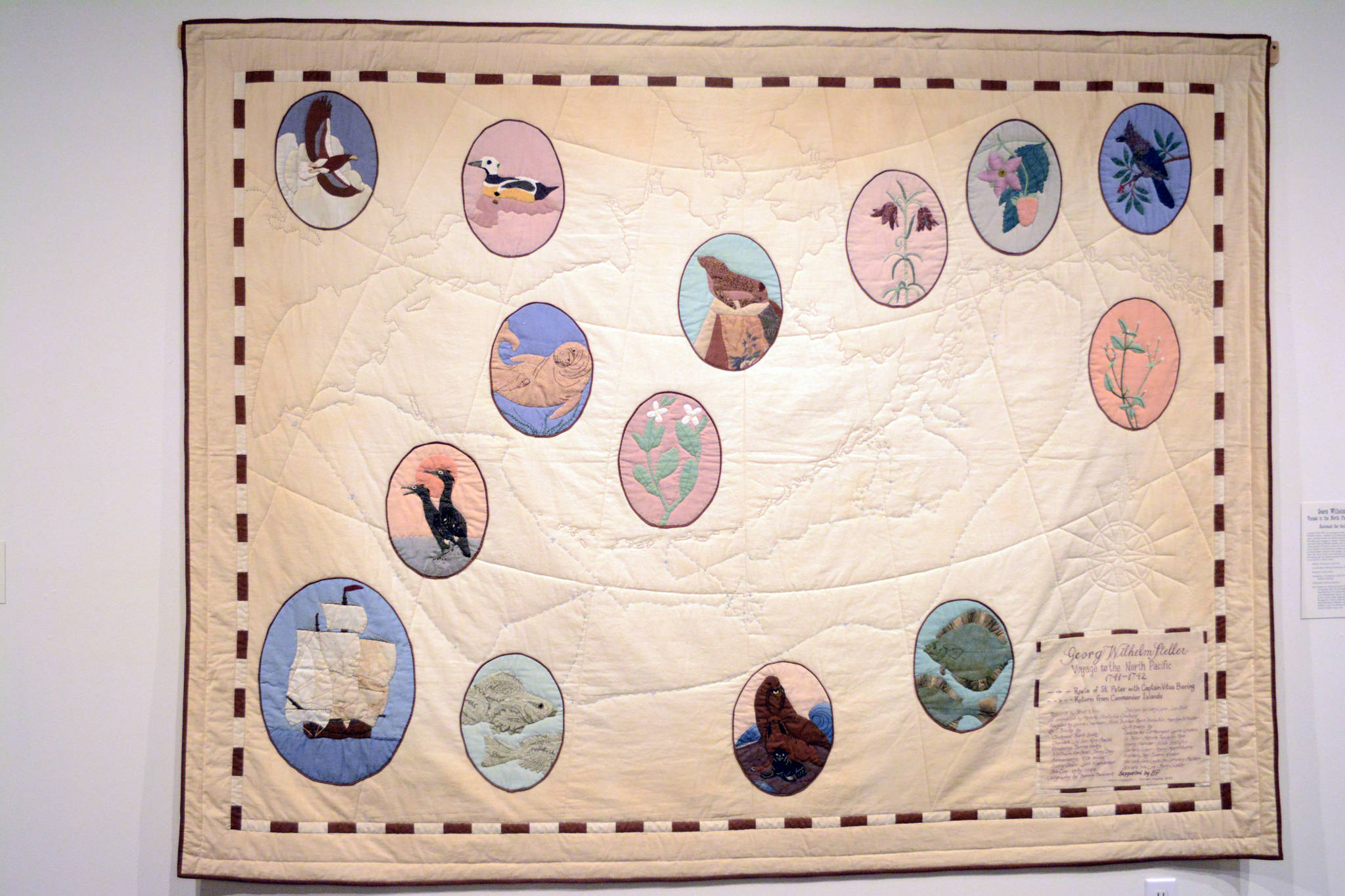
“Georg Wilhelm Steller: Voyage to the North Pacific 1741-42,” by the Kachemak Bay Quilters, done in 1991, commemorates the 250th anniversary of Bering’s voyage to Alaska that included Alaska’s first naturalist. Shown here Tuesday, Aug. 22, 2017, it shows the route of Bering’s voyage and the animals Steller first described. It’s part of the cARTography exhibit at the Pratt Museum, Homer, Alaska. (Photo by Michael Armstrong, Homer News)
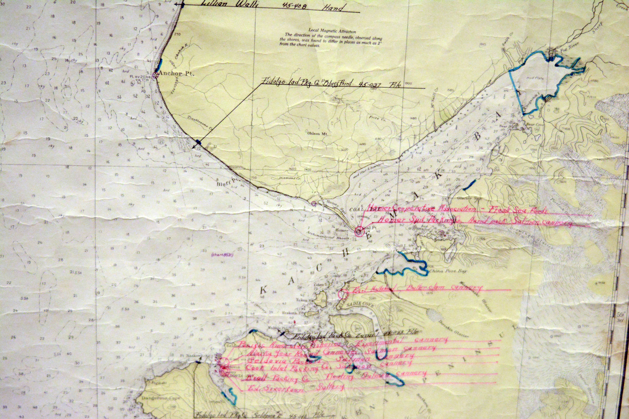
This 1944 map photographed Tuesday, Aug. 22, 2017 from the Pratt Museum exhibit cARTography includes notations showing areas open to fish traps (the areas with the blue lines) as well as locations of Kachemak Bay and Cook Inlet canneries. (Photo by Michael Armstrong, Homer News)
Kachemak Bay Research Reserve scientist Steve Baird used computer map making to show the retreat of Grewingk Glacier over time, as photographed Tuesday, Aug. 22, 2017. It’s part of the cARTography exhibit at the Pratt Museum, Homer, Alaska. (Photo by Michael Armstrong, Homer News)
